1
/
of
1
Wild Coast Publishing
#208 South Clayoquot Map
#208 South Clayoquot Map
Regular price
$18.95 CAD
Regular price
$18.95 CAD
Sale price
$18.95 CAD
Unit price
/
per
Couldn't load pickup availability
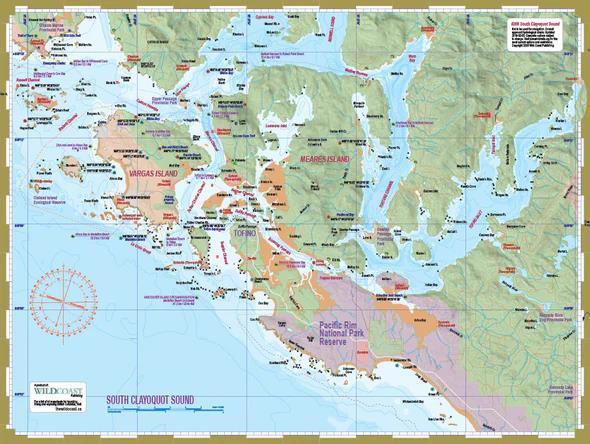
About South Clayoquot Sound: The paved highway to the West Coast ends at Tofino, a town with a unique mix of accessibility and wild geography which has helped it evolve from a sleepy fishing village into a West Coast cultural centre, surfing mecca and resort destination. That is all just window dressing, of course, for the natural beauty of Clayoquot Sound, the backdrop for any visit to this funky but busy little village. With numerous islands and passages to explore, it is a natural for on-water exploration by paddle of all skill levels. Turn to the outer coast to find sandy beaches, wild coastal islands and some challenging water. Head east and negotiate tidal passages and long, meandering rainforest fjords where you will find the quintessential images of West Coast ecology – ocean, water, forest, moss, rock and fog, all mixing brilliantly to portray an iconic ecology inherently wet but strikingly beautiful.
Less wet is the outer coast, which lies mostly outside the raincover created by the Clayoquot mountains and is characterized by sprawling sandy beaches where wolves still roam free in numbers. Watch for prints!
About this mapsheet: This mapsheet packages the inner waters of Clayoquot Sound including Tofino Inlet and routes to circumnavigate Meares Island, as well as routes to the beaches of Vargas Island and the islands and islets north to Whitesand Cove on Flores Island. Those venturing to Cow Bay and points north along Flores Island including Hot Springs Cove will want to have mapsheet #207 North Clayoquot Sound as well.
The mapsheet layout: The layout is a regional overview on the full page of one side, and on the other side a detailed closer-perspective view of the complex waterways around Tofino to Vargas Island. Also included are planning details such as expected water conditions, what to see and do, the First Nations context, launching information and background on Vargas Island Provincial Park.
The mapsheet construction: The mapsheet is created by Wild Coast Publishing using some of the latest technology available to provide a high-quality printed image on waterproof/durable synthetic polymer stock. The stock is picked as the best for the purpose, and is significantly thicker than most papers at 10 mil weight.
About the Clayoquot mapsheet series: Three mapsheets detail Clayoquot Sound from the south tip of Nootka Sound through Hesquiat Peninsula, past Flores and Vargas islands to Tofino. Each map is designed to complement one another with enough overlap to be useful on the water yet each providing oversight of a distinct section of the Clayoquot coast.
Share